Tuesday, 23 September 2014

Mt Zeil

A hard day hiking up NT's highest peak

First and foremost, big thanks to Jez for his track and trail notes and inspiration.
Check out his amazing blog at http://jez-hiking.blogspot.com.au/search/label/State%208

This story will be told via photo images and the accompanying captions......


Half the fun is getting there.....take the Tanami Road north from Alice Springs.
Turn left at Gary Junction Road and head towards Papunya
Turn left at the Glen Helen Station turnoff, then follow the mud map......


so easy,
except for the indistinct track
 and the overgrown track
 and the track obscured by fallen trees.......

.....until finally we reached our destination.
The Yellow Bucket!

Let's try and camp as close as we can to the base of the mountain.
So we follow the Yellow Bucket track to the creek bed.....
This looks like a good spot.
Time to put up the brand new Tarptent.
Oops, who didn't pack the tent pegs......
Sunset lights up the ranges, with moon rise on the horizon.
That's where we're heading tomorrow!
Campfire in the creek bed - chilli con carne for dinner 
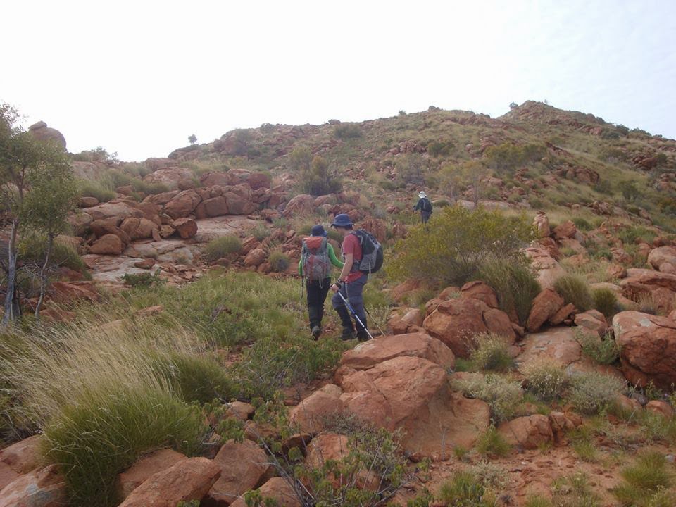
Leaving camp on Summit day - 8am


And the only way is up!
Wait for me lads!

Looking back towards camp

Still climbing...

And up onto the plateau.....

Hang on, I thought a plateau was flat!
Mt Zeil on the horizon - so close and yet so far!

Rocks and spinifex - thank heavens for Scarpas and gaiters.
Do they only make gaiters for legs?
Are there gaiters for buttocks?
Does anyone have some spare spinifex tongs?
Morning tea break.
Mt Zeil in the distance on the left.
Mt Sonder is on the distant horizon - right of centre
That's long enough - let's get moving!

So let me get this straight - you have to go down first to go up?
The first of many... I think you call them....undulations!


Shea and I sharing the Tail End Charlie duties.
Make a note of that tree lads,
 that's a trail marker to help us navigate the way back down


Up, up and more up!
Relentless.....
My energy levels are waning, nearly running on empty!
Not far from here, I stop and throw my walking poles down.
I cannot go on any further.....
Its 1230 - Decision time .....
still 25 mins from the summit.....
Abandon and turn back or
accept the risk of getting back after dark and push on to the top?
I haven't come this far to turn back now...
Let's finish this!
We have a quick lunch and push on...

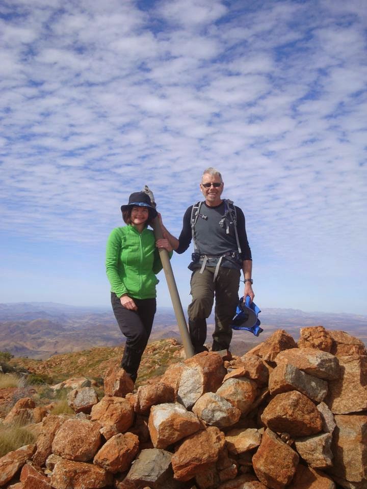
Summit!
Relieved, exhilarated, weary!
Who dares, wins!


Five hours up! And a 1500m climb!

Kissing the "Blarney Stone"!
The summit shot!

And another!
Celebrating!


And the log book entry - it's official now! Mission accomplished!
Looking back on past entries, only 3-4 groups summit each year.
Most with the goal to complete the State 8 - the highest peaks in each state and territory.
And yes, each group took a similar route to ours, taking about 5 hours for the ascent.
So we were right on target...

The Three Musketeers!


Mt Zeil summit - views to the east


Mt Zeil summit - view to the west

And now for the descent, retracing our steps.
Follow that ridge line!
The plan - a steady pace and maintain concentration!
Walk for 45 minutes - 10 minute snack and drink stop
Goal - to be off the mountain by dark!

Desert mountains bathed in afternoon sunshine
Halfway down - sticking to the plan!
We made it back to camp after sundown but still in twilight at 6pm.


A 10 hour off-trail hike. One of the hardest hikes I have done. Another one of the State 8 ticked off - 5 done - 3 to go!
A sense of achievement? - Yes! But did I enjoy it? Not really. I struggled mentally and physically. Not that I was unfit, maybe a little underprepared. Sometimes you have to take stock and count the cost. So the lessons to be learned:
Carry a little more water and food and snack more often. 
Hike was underestimated in terms of time and effort.
Carry an emergency beacon for remote hikes. We were very fortunate that nobody injured themselves.
Making memories is fun! This hike was one for the ages and it was fantastic to share the experience with friends.
Another Saturday Special Simon! Thanks for navigating!
Only the four of us will ever know what it was really like - thank you team - Jack, Simon and Shea!
My favourite photo of the day....and yes, I still love desert mountains!


Sunday, 21 September 2014

Wild Worumba Weekend

Another long weekend to spend exploring in the Flinders Ranges. This time at a place I had not heard of before, Worumba Station.

Worumba is located 30km east of Hawker. A land of beautiful contrasts, from craggy mountain peaks to rolling hills of pasture, with mallee bush and pine forest and river red gum lined creeks.
The weather dictated the walk planning. Both Saturday and Sunday mornings proved to be cold, damp and blustery, but after the sun burned off the low cloud, the afternoon walks were magnificent

Saturday morning we hiked to the summit of Mt Plantagenet, a slow hard climb given the weather. We detoured along the way into Box Canyon. The first hour was spent in creek beds to escape the icy winds, but after morning tea, it was time to tackle the spur line to reach the summit from the east. It was a tough 500 m in total whiteout conditions, with the wind roaring and a wind chill factor of 0c!!!! The noise of the wind even drowned out the mournful bagpipe music being played by Simon who quickly gave up his feeble attempts as his lips and fingertips were going numb.

Box Canyon - looking eastwards

Box Canyon - looking west

Misty Morn

Summit!


Gloves, beanies and coats were donned to keep warm and avoid hypothermia,  and after a few summit photos, we descended quickly along the western ridge. The western side was wild terrain, mainly spinifex and rock. Clambering and scrambling the only way to descend. We had lunch on the western face, with the clouds lifting to reveal distant views of the Flinders Ranges, from Dutchman's Stern to Mt Arden,  to the Elder Range and Wilpena Pound.
We headed back to the quarters hiking through native pine forest and stony creek beds.


Tree-hugging!

A meadow of green spinifex!

Stunning views!


The sunny afternoon enticed some of us out for another hike, this time to the south of the property. An unnamed peak, which became Hill 863 was the target. We even had to resort to stripping down to short sleeves for the climbing, the sun keeping up appearances for most of the afternoon! Plenty of kangaroos keeping a watchful eye on us from a distance. Again, the views or this summit did not disappoint, with the afternoon sun making silhouettes of the ranges on the horizon. The walk back in the fading afternoon light with the shadows lengthening was magical. It was like walking through a Hans Heysen painting.

Track....

Then off-trail!

Another summit!

A Heysen landscape!
(photo by Jo Chesher)


The Sunday walk plan was modified again due to the weather. During the morning, we hiked along creek beds to avoid the winds, and over green bald hills, that reminded me of Burra.
Jack, Peter and I detoured at the end to climb another hill, close to the shearers quarters. From the top, we took in the views of the valleys and rolling hills that surround the station homestead.

Bald Hills


Thanks for the photo, Peter!

Jack made it to the top first, again!

Rolling hills and valleys


Sunday afternoon's goal was to tackle Mt Craig. Again, the clouds had cleared, and again we walked in short sleeves. We followed dry creek beds and animal tracks as we approached from the east. We had a close encounter with a goat when we stopped for a drink, he sauntered down the hill and came close to only 10 meters away from us. And for a few minutes it was like a Mexican stand-off until he ran off to find his herd. Mt Craig certainly lives up to its name and Simon navigated us around to the northwest for the ascent to avoid numerous rocky outcrops.

Which way?

To the north


From here, the only was was up! A steep climb avoiding the spinifex ensued. The vegetation on the ascent reminded me of Patawarta Hill, but it was shorter, and steeper!
But, oh the views!!! I really do get "summit fever", and this time was no exception...
Magnificent 360c panorama - gorgeous!
Given the weekend had a Shakespearean theme and my initial plans for Mt Plantagenet had been thwarted by the atrocious weather,  it was a perfect opportunity to reveal my costume.
So I donned the fairy wings and tutu and danced around the summit cairn in my guise as Queen of the Fairies, from A Midsummer Night's Dream. My fellow hikers thought it was a mid- autumn afternoon's apparition! What can I say, Little Miss Sunshine was having fun in the sun!

Rocky mountain high!

Off with the fairies!

The two of us, one of us in a tutu!

Mt Plantagenet in the background, with moon rising!


Looking south to where we were going to descend looked like a dinosaur's spine, beautiful ancient rock mountain ridge tops, does it get any better than this!

Gorgeous!
(photo by Jo Chesher)


It was a slow descent owing to the steepness and a lot of rock scrambling. I managed to persuade a couple of the males of the group to don the tutus and wings to add some joviality to proceedings. We walked through Willow Waters Gorge and arrived back at the cars just as the sun was setting.

Looking back northwards to Mt Craig

Worumba is highly recommended for a Flinders Ranges get-away from it all break.
Check out their website: http://www.worumba.com/

Saturday, 13 September 2014

Nearly didn't make it home!

Hei kona ra!!!

Travel Day
Nelson - Auckland - Sydney - Adelaide
Stocked up with duty free alcohol and perfume in Auckland

Secretly, I've always wanted to be one of those people whose name you hear over the airport loudspeaker being requested to board the airplane - I think the call goes something like this:
"Paging Mrs Vicki Cox - This is your final call for Flight number QF?? please make your way to Gate number 2. Your plane is fully boarded and is waiting for you!"
Well if I'd only heard the call, I would have made my way to the Gate!
We were seated in an adjoining departure lounge, next to Gate 3 as the lounge for Gate 2 was full. Neither Jack or I heard any of the boarding calls. It was only when we checked our watches, looked up at the signs and saw FLIGHT CLOSED that we got a little panicked. We approached the gate, to be berated by the aircraft ground staff that the flight was closed. We explained that we had not heard the calls to board, and only after arguing the point with ever increasing vocal volume, were we granted entry through the gate.
Walking down the aisle to our seats, I felt I was being scrutinised by one hundred pairs of eyes!!!!
Jack was fuming about the attitude of the staff, and they only added fuel to the fire when, as we were sitting down in our allocated seats on the aircraft, there was an announcement over the speakers by the flight crew that the flight departure was stalled due to late customers and the subsequent queue of aircraft on the runway for take-off.

Oh well, makes for a good story!

Fabulous time exploring some of the South Island - Routeburn Track, Fox Glacier and Nelson Lakes my highlights!


Torrent Bay to Marahau

Due to the morning high tides, we had to walk the extra 5 kms up and around the estuary, making it a 15km hike to finish the trail.
This is the easiest section of the coastal track with panoramic views across Tasman Bay to Nelson. Along the way we again passed pristine bays and beaches all covered with the trademark golden sand.
Around midday we stopped for lunch at a sheltered beach with views of some of the numerous small islands dotted along the coast.
It was here that I shared the story the walking stick that I had been carrying with me from the start of the trail, remembering Warren Bonython and his legacy, the Heysen Trail. Grateful for friends sharing their love of hiking with me, bringing me to this place, to enjoy and savour the great outdoors!


It was a gradual descent down into Marahau and after crossing the estuary on an elevated boardwalk, we reached the end of the trail. I left the walking stick behind the official Abel Tasman Coastal Walk sign, hoping that it will be put to good use by another hiker.


Our driver collected us from the appointed pickup zone at the appointed hour of 2pm. Stopped off at the office to gather our belongings and then delivered to our accommodation in Nelson.
Took advantage of the spa bath at the hotel and enjoyed a pub meal for dinner.
Enjoyed the Abel Tasman Coastal Track - a little decadent doing the guided walk, but nice to sample the best of NZ South Island hospitality.

Torrent Bay

Favourable tide conditions this morning to take advantage of kayaking in the estuary up the Falls River. We spent an hour or so on the water which was our first time kayaking. Fun way of exploring the river.


We were in for a special treat for lunch. Craig Wilson, the owner of the company had organised a special seafood luncheon for a charter group of French tourists. The chefs had prepared a feast, and you could almost hear the dining table groaning over the weight of the platters of seafood - a bountiful spread with fine wines to accompany the food. It was absolutely superb!
The afternoon optional activity was a walk across the now-drained estuary over to the golden expanse of Anchorage beach and picturesque Te Pukatea Cove. We enjoyed a leisurely walk in beautiful sunshine. We met another Wilson's guide at Te Pukatea Cove who was escorting a couple kayaking to Torrent Bay, so we would have extra company that night.


After we returned we had a brief swim at Torrent Bay. It took awhile to submerge ourselves as the tide was out and took at least 10 mins to get out to waist height water!. Still nice to enjoy this superb coast!
Dinner was another culinary delight. The kayaking couple were also from Adelaide and brought news from home including the state election results. We whiled away the evening with a game of Scrabble, with yours truly winning!